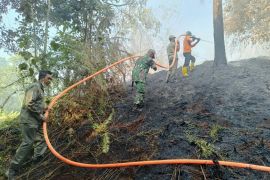
Based on monitoring conducted by the Terra and Aqua satellites, six hotspots were found in South Sumatra, four in Lampung, two in Bangka Belitung Islands, and one in West Sumatra, Budi Satria, the head of the Koto Tabang meteorology section, noted.
However, the NOAA-18 satellite detected 36 hotspots across Sumatra Island on Wednesday morning.
"The NOAA-18 satellite detected 20 hotspots in Bangka Belitung Islands, six in Lampung, six in South Sumatra, and four in Jambi," he remarked.
In the meantime, the number of hotspots in Indonesia has, in general, decreased significantly over the last few days.
"The number of hotspots has decreased significantly," Sutopo Purwo Nugroho, a spokesman of the National Disaster Mitigation Agency (BNPB), recently reported.
In addition, rains received in the past couple of days have improved the air quality and visibility in Sumatra and Kalimantan.
Moreover, the BNPB had seeded 284.9 tons of salt (NaCl) in the skies above Sumatra and Kalimantan islands to produce artificial rain as part of the efforts to extinguish forest and land fires in the two regions.(*)
Editor: Heru Purwanto
Copyright © ANTARA 2015


