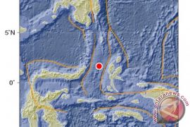
The quake`s epicenter was located at 2.91 degrees southern latitude and 129.67 degrees eastern longitude, around 185 Km northeast of Ambon, and at a depth of 25 Km, Head of the Ambon Geophysics Station Benny Sipolo said here on Saturday.
The temblor did not trigger a tsunami, Sipolo said.
Indonesia is prone to seismic upheavals due to its location on the so-called Pacific "Ring of Fire", an arc of volcanoes and fault lines encircling the Pacific Basin. Maluku province lies at the meeting point of the country`s two main bp;ano chains.
Sipolo said none of quakes that had affected Maluku had the potential of causing a tsunami. Most of the quakes affecting the province so far were local and shallow, measuring three to four on the Modified Mercalli Intensity (MMI).
Quake-prone areas in Maluku include its southeastern parts, Ambon, Seram and Buru Islands.
Meanwhile, Bali was rocked by an earthquake measuring 6.8 on the Richter scale on October 13, 2011.
The Meteorology, Climatology and Geophysics Agency (BMKG) said the quake was centered 143 km southwest of Dua Dua, Bali, at a depth of 10 km.
But the temblor did not have the potential to cause a tsunami.
At least 46 people have been taken to Sanglah Hospital in Bali following the quake.
(Uu.F001/HAJM)
Editor: Priyambodo RH
Copyright © ANTARA 2011


